


|
|
|
|
  
|
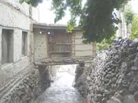
travel By Durdana Ali Malik "You will be staying in the Rani's room on the second floor,' enthused Karim as I walked in stunned silence through the charming Shigar Fort, reminiscent of ancient stone-walled Dickenson masonry. The room had two small windows (small -- to keep the cold out in freezing winters, not because the Raja was stingy or paranoid). One window opened out on a tumbling over rocks and the other window opened onto the royal orchard, which had cherry and apricot trees in blossom, with purple irises dotting the landscape.
On top of the world A first timer to the Northern Areas who left his heart behind By Adnan Rehmat The first reality check for an ordinary Pakistani when
flying to Northern Areas is to realise that Swat and Chitral are not part of
it (they firmly belong to NWFP geography). The second is to find yourself
kicking yourself for treating the vague notion of Northern Areas being in
Taliban control and hence part of the conflict currently tearing Pakistan
apart as a reality even though the region is the most peaceful place in the
country; its people extraordinarily gracious and hospitable as
service-oriented as only true tourist destinations can be. The natural
corollary of the above two is cursing yourself for not visiting sooner. And everywhere I went on an eight-day trip to the region (the only place, I'm ashamed to admit, in the country I hadn't been to -- 42 years wasted, I guess) -- with my wife Ismat Jabeen and children, son Miran and daughter Sunaina swooning over the place -- we encountered the undertones of frustration at being greatly misunderstood by most Pakistanis and confusing their region with another (NWFP). Once you provoke the topic, the first protest is about the ridiculousness of the nomenclature. "What kind of name is 'Northern Areas'?" is the common refrain (the walls in major towns are painted with this question, awaiting an answer that is not coming). It's Gilgit-Baltistan, most insist. Some others would rather call their region "Karakoram." Which makes one think really -- what kind of country calls large swathes of its territories "Northern Areas", "North West Frontier Province," "Federally Administered Tribal Areas," "Federally Administered Provincial Areas." etc. All these areas are fiercely beautiful but frustrations mar beauty in our paradise. Once you get over the political frustrations (another one:
why isn't 'Northern Areas' represented in National Assembly or Senate?)
articulated on the walls in major towns, you are stunned by the paramount
beauty of the regions. Snow-capped majestic mountains, silent like sentinels
but giving Clearly climate change is also a citizen of the Northern Areas. To an Islamabadiite like me, haunted by chronic water shortages, it seemed unfair so much water was simply going somewhere other than my city. I caught myself thinking five times a day about ways to get some of it to Islamabad! Skardu For the first timer to the Northern Areas, the adventure
begins with your PIA flight (once it manages to fly -- we were victims of
three days of cancelled flights). There are daily flights to Skardu and
Gilgit. We took the former. You fly over some of the highest peaks -- on a
clear day you can see K-2, which much to our delight we did -- in the world
(fact: 40 of the 50 highest peaks in the world are in Pakistan four of which
exceed 8,000 meters, including K-2, the second highest The flat Skardu Valley ringed by tall snow-peaks is where the mighty Indus is an 'infant'. It barely seems to move across the immense, 40km long, 10km wide valley and carpeted with silvery grey sand dunes. In between dust storms the land seems cleansed and freeze-dried, and the light is intense. Skardu is on a ledge at the foot of Karpucho, a rock sticking 300m out of the plain where there is a beautiful emerald coloured lake called Karpucho Lake. The town has been a mountaineers' haunt for over 150
years, and a military headquarters since Partition, but it's also the base
for many classic Karakoram treks and even some good day trips. It We got out of the airport and headed straight to Shigar, about 80km from Skardu. We stayed at Shigar Fort, a 400-year fort turned into a resort in late 2005 following an intensive six-year restoration undertaken by Aga Khan Cultural Service Pakistan. Originally known as Fong-Khar, which in the local Balti language means "Palace on the Rock," this Raja fort-palace has been brought back to life following a careful strategy of adaptive re-use and restoration. The result is a combination of authentic original 17th century architecture together with the modern amenities and services of a luxury guest- house. The next two days we spent exploring some of spectacular scenery and places including the serendipitous Sadpara Lake. Sadly for us, the road to the gigantic Deosai national park plains was closed. Hunza On our third day we left by road for Hunza. It was a 12 hour drive -- the spectacular Skardu Highway leading to Gilgit, a snaking road carved out of stones on neverending mountains with the breathtaking Skardu river (embracing various tributaries to what becomes Indus down south). It was supposed to be a 9-hour journey, prolonged by a major effort by the Chinese (we saw hundreds of Chinese workers cutting the mountains -- there were long minutes when I found it hard to believe we were not in China) to double the road width to an average of 30 feet. At a halfway point somewhere we climbed onto the fabled Karakoram Highway, a bit withered by its every inch deserving the fabled status. We passed by Gilgit but did not stop and a final 3-hour drive from Gilgit got us to misty, leafy Hunza. The Hunza Valley is the crown jewel of the empire of Karakoram. The continuous sweep from the Hunza River through mighty, grey-brown slopes and up to snowy peaks, including the jaw-dropping beautiful 7,800 meter Rakaposhi, is a reminder of the river's deep slice across the Karakoram. Even through the spring was a few weeks off, we found the region's famous fruit trees beginning to erupt in bounty, particularly plums, apples, peaches and cherries. Snaking across the slopes in surprisingly straight lines
is Hunza's hallmark, the precision-made stone channels on which the valley's
life depends. Carrying glacier meltwater to tiny stone-walled fields, they
have transformed a 'mountain desert' with few horizontal surfaces into a
breadbasket. Their paths on the high rock faces are revealed by thin lines of
vegetation, and patches of green are visible on the most improbable walls and
ledges. Irrigation sustains orchards of Hunza's famous apricots, as well as
peaches, plums, apples, grapes, cherries and walnuts. Irrigation also waters
the fields of maize and wheat, and the ever-present poplars, a fast-growing
source of fodder, firewood and timber. Added to the beauty is a kind of mythology about Hunza's isolation and purity, spawned by James Hilton's 1933 novel Lost Horizon, nourished in films about the lost kingdom of Shangri-la, and fostered in the 1970s by media stories of extraordinary health and longevity. The Karakoram Highway itself has put an end to Hunza's isolation, and while the Garden of Eden image ignores a rather bloody history, this hardly alters Hunza's appeal. Baltit is Hunza's ancient capital. Its magnificent fort, on a throne-like ridge with Ultar Nala yawning behind it, has always been the kingdom's focal point. The fort served as the royal palace for over 750 years until last century, when sounder quarters were built below in what came to be called Karimabad. The name is now also used for Baltit and the complex of ancient tribal hamlets around it. Karakoram Highway has promoted tourism and Karimabad has prospered and the bazaar has filled with hotels, restaurants, travel agencies and handicraft shops. The Karimabad bazaar cobble-stoned and with neat-rowed handicraft souvenir shops give an air of ancien regime mixed European chic. The showstopper in Hunza is the 13th century, recently renovated Baltit Fort, perched atop the valley and visible for miles and lies around. Once the centre of dynastic politics and known for its resistance to Raj-era British colonial push, the fort began to deteriorate in mid-16th century. The name Baltit probably dates from this time. The fort took on its present appearance only in the last century or so. Mir Nazim Khan, ruler of the region, started adding walls and rooms, drapes, fireplaces, balconies and tinted windows. He had the outer walls whitewashed, dramatically raising the fort's visual impact from all over the valley. Also added were a rooftop dais, where royal councils were held in good weather, and the 'lantern' or skylight. Nazim's grandson moved to modern quarters in Karimabad in 1945. However, by the time Karakoram Highway travellers first saw the fort in the 1980s it was an abandoned shell, stripped of anything of value and verging on collapse. From 1990 to 1996 it was effectively taken apart stone by stone and reassembled. This was a painstaking effort using advanced preservation principles developed in Europe, while retaining the unique construction and earthquake-proofing techniques pioneered by the fort's original builders. The result is impressive and the renovation work almost invisible. Several rooms have exhibits of clothing and old photos, plus utensils and furnishings donated by local people. Visitors get a half-hour tour with a knowledgeable local guide (you cannot go in without one), and interested persons can use the library. Tickets are sold -- Rs 100 for locals -- at a small kiosk below the fort and it is worth noting that the fort's administration is funded solely by these ticket sales. Gilgit After two days in Hunza, it was time to move on to Gilgit, which is probably best known for the 8,125 meter massif of Nanga Parbat, the eighth-highest mountain in the world. Locals call it Diamir. It also includes the remote Astor Valley, running along the east side of Nanga Parbat to the Indus, and 100km of the Indus Valley from there to the NWFP line, taking in some of Pakistan's harshest -- and most perhaps most beautiful -- terrain. Unlike the rustic, rugged nature of faraway and exotic Skardu and Hunza, Gilgit is more like a cross among Quetta, Abbotabad and Peshawar. Gilgit city itself is the capital of Northern Areas and a major hub of the Karakoram Highway. This bustling frontier town (even though population is just about 70,000) offers a good smattering of shopping and restaurants. And oh the giant chinar (maple) trees! They are everywhere, giving the city a distinct heavy-leafed charm. The town is an interesting melting pot of northern peoples. Its bazaars attract traders from all over Pakistan and China. A variety of languages are spoken as Chinese silk and chinaware, fabrics, handicrafts, foodstuff and spices change hands. The round-the-year snow-covered peak of Rakaposhi stands guard at the eastern end of town (like Faisal Mosque in Islamabad, it is visible from most parts of town), and a semi circle of barren peaks (my friend, The News' Gilgit correspondent Shabbir Mir and his brother Ahsanullah Mir, the Karakoram University registrar, both of whom were our gracious hosts, told us they were over 4,000 meters high) enclose the valley on other three sides. Gilgit gets very little rainfall annually; so all agriculture land is irrigated with water from melting snows from higher altitudes. The Gilgit River slices across the breast of the city like a drugged snake, its waters sparkling under a hot sun (at least in mid-June, when we found ourselves there). The sightseeing excursions not to be missed are jaunts to Naltar, Kargah and Bagrots. After our exhausting but exhilarating eight days, it was time to go home. As our 50-seater PIA throttled into action and adroitly soared into the air over the Gilgit River, for a moment I thought it would take us to the top of the majestic Rakaposhi but it cut a long loop and purposefully turned towards Islamabad. But I think I left my heart behind.
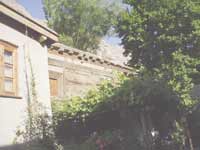
A recent sojourn to the Shigar Fort in Baltistan reiterates that most Pakistanis miss out the most stunning sights of Pakistan By Durdana Ali Malik "You will be staying in the Rani's room on the second floor,' enthused Karim as I walked in stunned silence through the charming Shigar Fort, reminiscent of ancient stone-walled Dickenson masonry. The room had two small windows (small -- to keep the cold
out in freezing winters, not because the Raja was stingy or paranoid). One
window opened out on a tumbling over rocks and the other window opened onto
the royal orchard, which had cherry and apricot trees in blossom, with purple
irises dotting the landscape. Rather breathless by now, with the natural beauty surrounding me, I kind of swooned onto a smartly made bed and looked around me. The ancient room had juniper beams, alcoves with an occasional wooden Balti artifact placed in it, and walnut wooden floors. Guests to this residence are supplied with special fabric slippers in their rooms so that they don't damage the ancient walnut floors. And of course we all know the actual comfort zone in our lives is a good bathroom. The bathroom may have been tiny but sparkled with the latest plumbing and plush fittings (warm water in the muslim shower). The mandatory pompous white bathrobe that is offered by five-star hotels was also there. (Would some hotelier please replace it with a practical towelling or linen jubba or nightie for female users please?) Of the much-revered creative holidays I've had, this year's sojourn to the Shigar Fort Residence in Baltistan, reiterated my belief that most Pakistanis (tourists and expats) really miss out on the most stunning, approachable, sights of Pakistan. I would like to mention that I was alone on this trip not because I lack friends or family, but because they seriously thought I had gone crazy. "Who holidays in a war zone?" was the refrain I got from almost everyone (strangers included) who heard I was going north. Then I started carrying a map around "See the red zone, that's Swat and Malakand. Almost 10 hours and hundreds of miles away, see this Green Zone see, see this is where I'm going; its Gilgit and Baltistan." I apologise for sounding like I was talking to a Montessori group. But really people, you deserved it. A 50-minute Boeing flight over the spectacular snow-clad Nanga Parbat range landed me in Skardu. The minute you step out of the plane, a sweet smell welcomes you. The roads are lined with lovely green trees whose blossoms release an ever-pervading fragrance. In Balti the tree is called Ber. A 40-minute drive in a comfortable 4-wheeler, through Skardu city and impressive stretches of spectacular vistas, on near perfect roads took me straight to the Shigar valley, where resided the Raja of the Shigar Fort. Conservation experts from all over Pakistan renovated the 400-year-old Shigar Fort Palace Residence, built on a huge rock, over approximately six years. It was handed over to the Serena Hotels last year. This is when the place became truly exceptional -- serving superb meals in charming balconies overlooking the streams or in the lush gardens with a sheer rock view; fresh trout, organic salads, cherries and apricots from its own gardens and superb service. I wasn't surprised to see youngsters from Islamabad, female embassy staffers, often travelling alone. As I took a leisurely walk in the surrounding village, I realised the entire area had been touched up by the conservationists -- sites included imambargahs that I'm sure were Buddhist temples at some time in the past. One of the renovated sites has also won a much-coveted UNESCO Conservation award recently. On a morning drive to see neighbouring lakes, Satpara and Kachura, I was honoured to know that Raja Mohammad Ali Shah Saba, who lives next to the Fort would be hitching a ride with me until downtown Skardu. Never before has a blue-blooded Raja asked me for a lift. History has been created. The 70-year-old Raja Sahib loves to talk and I was delighted to learn so much about the family history. He informs me that the area was rich in wildlife including Urial, Ibex and cheetahs; and that he must have shot at least 500 to 600 urials in his hunting heydays. "So, you're responsible for the extinct wildlife here," I quip, as he gets off at his stop. "No, its these helis (helicopters) that fly over our heads." he responds.
|
|
 the natives a taller, firmer demeanour, clear air (the bluest blue sky I've
seen anywhere -- and I've travelled all five continents, mind you) and oh the
abundant water. Sparkling water originating from glaciers and coursing
through mini channels in your street, the sweetest therapy money can't buy.
Imagine being lulled to sleep each night by the soothing sound of flowing
water running over the pebbles under your window. The natives, nonetheless,
say the water flows have decreased in recent years.
the natives a taller, firmer demeanour, clear air (the bluest blue sky I've
seen anywhere -- and I've travelled all five continents, mind you) and oh the
abundant water. Sparkling water originating from glaciers and coursing
through mini channels in your street, the sweetest therapy money can't buy.
Imagine being lulled to sleep each night by the soothing sound of flowing
water running over the pebbles under your window. The natives, nonetheless,
say the water flows have decreased in recent years. mountain peak in the world at 8,611 meters). The problem with the flight is
that it ends too soon, 45 minutes. The curving landing approach to Skardu
airport is out of this world. When it lands, you find yourself on a runway
surrounded on all sides by snow-capped mountains so tall you have to crane
your neck to take them in. Then you take a bus to go to the airport, which
takes five minutes to become visible!
mountain peak in the world at 8,611 meters). The problem with the flight is
that it ends too soon, 45 minutes. The curving landing approach to Skardu
airport is out of this world. When it lands, you find yourself on a runway
surrounded on all sides by snow-capped mountains so tall you have to crane
your neck to take them in. Then you take a bus to go to the airport, which
takes five minutes to become visible!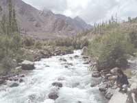 is from here that two days travel by road takes you to a place from where it
takes you a 5-day trek to reach K-2. The capital of Baltistan, Skardu finds a
cosy home at a height of 2,300 meters in the backdrop of the great peaks of
the Karakoram mountain range. Baltistan itself is known as the Little Tibet
since its life-style reflects that of the roof of the World and Land of
Lamas. It borders on the Chinese province of Xinjiang and Indian-administered
Kashmir.
is from here that two days travel by road takes you to a place from where it
takes you a 5-day trek to reach K-2. The capital of Baltistan, Skardu finds a
cosy home at a height of 2,300 meters in the backdrop of the great peaks of
the Karakoram mountain range. Baltistan itself is known as the Little Tibet
since its life-style reflects that of the roof of the World and Land of
Lamas. It borders on the Chinese province of Xinjiang and Indian-administered
Kashmir.