


|
|
|
|
| |
|
|
Editorial joys
Trek by chance hardships Ascent
of a woman
We at TNS have just
managed to capture a fraction of it. Trekking in Pakistan is a lot bigger
than people think, and of course we are not talking about the countrys
potential here. This being understood to
be the heart of trekking season from May to October to be precise it
was about time we did a Special Report to give our readers a sense of what
an escape it provides to the trekking junkies. Together they run into
thousands, for sure, if not hundreds of thousands, defying our plain lack of
sense of adventure. Every year, around this
time, we get to hear a near and dear one becoming part of a trekking group;
members of the group are not necessarily the best of friends. In a
mysterious way (online mostly), they connect with each other. The logistics
get worked out rather easily; the porters, the guides, the equipment, the
supplies and the transport is only a matter of days once the destination or
route is decided. Women are as much a part of these expeditions as
men. Contrary to our
perceptions, a whole tourism industry seems fully operational the moment you
google the phrase trekking in Pakistan. Heartfelt, enthusiastic and
well-written blogs would shake even the worst of couch potatoes. But wait;
this is just the beginning. A man running an equipment shop in Lahore
estimates that as many as 200-300 people have already left for Concordia
one of the most ambitious treks this year. Talking of trekking season
means that most of this activity is confined to the treks in the North
mostly in the Himalayas, Hindu Kush and Karakoram in particular months. But
ace travel writer Salman Rashid is keen to mention the splendid treks in
Khirthar Mountains of Sindh, Suleman Mountains in southern Punjab and the
equally breathtaking and do-able ranges in Balochistan. If his word is
heard, trekking will be an all the year round activity in this part of the
world and bring so many more foreign tourists too. For the trekkers, its
an out of the world experience each time, away from the humdrum urban lives.
A few months pass and they start looking for new destinations. The family ties that used
to bind and keep people together in this part of the world are being
redefined as more and more trekkers share the joys and hardships of
trekking. This other world involves not just adventure; it involves
patience, interpersonal connections, meeting simple mountain people leading
harsh lives and yet keeping their humaneness intact. It is an exposure of
another kind. And the trekkers are fast learning to organise trips
themselves. Over to the wondrous ways of trekking.
Trekking, as we know it,
is actually a spin-off of the work of the early 19th century European
explorers, surveyors and map-makers. Hiring local hunters and shepherds as
guides, they followed the barely marked trails plied by earlier natives. The
first adventurers, in the true sense, were mountaineers who had little to do
with exploration and map-making, but were obsessed with climbing the virgin
snows of the Himalayas-Karakoram-Hindu Kush system. By the 1920s, yet another
breed of adventurer was roaming this great knot of high peaks and glaciers.
This bunch did not climb per se. Driven by curiosity, they simply walked the
trails. Their purpose was largely historical and sociological studies and
they worked on shoestring budgets. There was, of course, another sub-caste:
wealthy, highly educated, cultured persons of the world. Theirs was the best
written record. Mountain walking or
trekking, whatever you may call it, in the modern sense, began in the 1950s.
Its practitioners were a breed not as exalted as hardcore mountaineers; they
had no desire to stand on untrammelled snow. Their wish was to get into the
vicinity of the throne rooms of mountain gods and gaze at them from the
closest possible quarters. In our part of the world,
the great trekking areas of the Western Himalayas, Karakoram and Hindu Kush
mountains have been an attraction ever since trekking came of age. Here we
had the all time favourite route from Skardu via Askole and the Baltoro
Glacier to Concordia. This breathtaking confluence of several glaciers got
its name from the explorer Martin Conway in 1892. The attraction here is the
majestic panorama of Chhogho Ri (K-2) to the north; the four Gasherbrum
peaks to the east and Chhogho Lingtza (incorrectly Chogolisa) to the
southeast. Abutting this magnificent peak, sit the Masherbrum peaks in a
crystal line on the south. With so much to offer,
this must surely be the most walked route in the entire country. Others such
as the Biafo-Hisper Pass-Nagar route stand as close second for frequency of
trekkers. Many come to see what Conway saw when he became the first European
surveyor here. Few know that long before Conway, raiders from Nagar
periodically came down on Askole to rob for foodstuffs. Further to the north,
hardcore trekkers take the shepherds route from Shimshal over the pass by
the same name to Shuwert. Tough as it is, especially in its lower reach,
this is the litmus test that sets the minnows apart from the real trekker.
The prize is picturesque Shuwert; the only summer pastures in Pakistan that,
geographically speaking, lie in Central Asia. That is, north of the Great
Asiatic Divide. In Hindu Kush, there are
rather easier trails of varied interest for trekkers. The one north from
Chitral to Broghal Pass into Wakhan was a popular one which slipped into
the background in the early 1980s because of the war in Afghanistan. If it
looked set to recover after the Soviet withdrawal, it lost out again after
9/11 and the proximity to the zone of fighting. Currently, another problem
assails this great route. Since Pakistan works on principles of economy that
are followed nowhere else, the scarcity of trekkers has tremendously hiked
up the cost. Whereas normally a couple of porters per person would cost
about Rs 10,000 for the trek, the asking price earlier this year was
reportedly Rs 125,000 per person! Naturally, there were no takers. But there is something to
be said for the hill walker who will hump his 25 kilogram backpack and go it
alone. For him neither Broghal nor Shimshal means any expenditure. Of this
breed, there seems to be a serious deficit in Pakistan. The round trek of Nanga
Parbat and the several treks in Swat Kohistan are similarly well-trodden,
accessible and fairly easy. But all these routes have now been virtually
flogged to death. Of recent years, the
several passes around Sim Gang Glacier (aka Snow Lake) have received the
attention of both Pakistani and foreign trekkers. So far as local
adventurers were concerned, this was mainly because of the availability of
the Leomann maps of the region which, though not topographical, provide
essential information and have helped open up new routes. I have seen foreign
trekking parties sometimes in possession of first-class topographical maps
of one-inch-is-to-a-mile scale. This is the premium sheet necessary for the
adventurer who would go it alone without guide or porter. Unfortunately,
because of our security state mentality, Pakistanis are denied access to
this map. Now, the knot of mountains
in the north is a summer trekking region. What just a handful of us realise
is that the south, the Khirthar Mountains of Sindh, the Suleman Mountains of
southern Punjab and the several ranges in Balochistan are a prize waiting
for the one who would go hill walking in winter in a region of which little
is known outside. In the Khirthar, there are
several east-west passes, some like the Moola are jeepable, others only for
foot traffic. Here one finds long hours of walking through waterless tracts
only to be suddenly confronted with deep ponds of liquid emerald teeming
with fish and sometimes crocodiles and gavials. Here are refreshing
oases of prosopis and tacoma rich with birdsong. All is not just harsh, arid
landscape as one is led to believe. There are several
climbable peaks in the Khirthar. Kutte ji Qabar (Dogs Grave), Mian Ghun,
and dozens of unnamed ones are all accessible through some of the most
dramatic and little seen landscapes. Northwards, where the Khirthar runs
into the Central Brahui Mountains, there are yet more peaks and valleys that
await the crunch of the hill walkers boots. No Khirthar summit rises
any higher than 7,200 metres while the Central Brahui Mountains peak at
3,277 metres on Koh e Maran (Mountain of Snakes), a remarkably beautiful
oblong with a coned summit. In this very range, there are nearly a dozen
peaks upwards of 2,800 metres. Moreover, there are any number of migratory
tracks followed by Brahui and Baloch shepherds on there twice annual
transhumance. As well as that, river valleys like the Mashkai and Hingol are
places straight out of an Allan Quartermain yarn. Sadly, the current state
of unrest in Balochistan puts these mountains out of the reach of the non-Baloch. In southwest Punjab,
despite its nearness to lawless South Waziristan, one can wander for months
on end in the Suleman Hills. Nowhere higher than 2,328 metres, the range is
a series of highs and troughs that daily whip up fantastic weather
conditions in the afternoon. Here, one is treated almost nightly to the most
incredible firestorms. This range culminates in
the 3,379-metre Takht e Suleman, a virtually waterless mountain. Once
thickly covered with chilghoza pine (now sadly much depleted) which thrives
in high altitude aridity, this is certainly the most difficult trek in the
south. As opposed to the
well-trodden trails of Gilgit-Baltistan and Chitral, Balochistan, Sindh and
southwest Punjab offer a novel trekking experience where only the intrepid
may pass. This is truly a country where travel is still anxiety-making laced
with a huge dose of uncertainty for, no one ever having trekked in these
regions, the only source of information is the local guide. It needs be said
that if the guide is a Baloch or a Brahui, then one is in the securest of
hands. These two must surely rank as the most reliable and trustworthy races
in the country. Another unknown quantity
is the area surrounding Ziarat, east of Quetta. Famous for its juniper
forests which, incidentally, cover over 50,000 hectares, the country is a
hill walkers dream. Uncrowded, quiet, scented with the sweet fragrance of
juniper and dozens of wild herbs, this is a country where one is actually
all by oneself. Since the trails are known only to forest guards and local
shepherds, a guide is necessary for which the office of the DFO at Ziarat
can be helpful.
Trek by
chance One summer, forced by
ennui of urban life and without knowing exactly where to go, I headed in the
general direction of Muzaffarabad but finding it to be dull and boring made
inquiries as to go further. Since I had never been to the Leepa Valley I was
told that I should go to Garhi Dupptta from where some mode of transport
would be available to take me to Leepa. In full innocence and
armed by my enthusiasm, I landed at the last village which was accessible
through public transport. On reaching the village which consisted of a few
roadside khokhas, I looked around at the general sight of desperate poverty
and utter isolation of the place and made a few inquiries about heading
further up. All the shopkeepers were
cagey and told me in whispers that there was no public transport and that I
would have to take a ride on a dala (open truck carrying timbre) or else
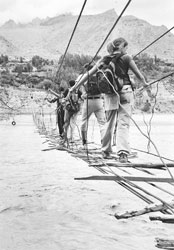
walk it. I looked at the awesome
mountain in front of me which surged with great imminence and calculated in
my mind the time it wou My experience had taught
me never to take the locals assessment at face value, especially of time
and distance and to multiply it by ten. So, if they said three hours for us
the city dwellers it could easily mean 30. As I was making inquiries,
a person appeared on the scene and as he looked slightly more groomed I
fired my set of questions. He seemed more sympathetic and answered me in
more definite terms. Our conversation continued for more than ten minutes,
so he invited me to his hut two hundred feet from the main road for a
detailed discussion over a cup of tea. I went into the hut and found two
other men as well. Very soon, only these two remained while my initial
acquaintance disappeared on the pretext of getting tea that never seemed to
arrive. He had also shut the door and now the only source of light was the
barred window. After a while I realised
that the two men were actually asking me questions set in an interrogative
mode. Who was I, what was I doing there, why did I want to visit Leepa, what
was my intention, etc. As the question-answer session prolonged, I wanted to
leave but was told that I could not. The interrogation session continued and
no tea arrived. Then both the men left and bolted the door from the outside.
The sun had started to go
down. It was early evening and I had a sense of being in custody. At evening
time, the door opened and another man made an appearance. He sat down and
started to question me again. He seemed more menacing than the other two and
appeared to be holding a senior rank. I had sensed by then that
these personnel were not ordinary civilians but from some agency. It
did not strike me that they could also be hostage takers or part of some
mafia/gang. It had become dark and
there was no lamp inside the hut. The person doubted every word of mine.
Seeing the beautiful Kashmir, exploring the country on my own etc only added
to his disbelief. He left, saying he would return in the morning,
threatening that if I made an attempt to escape it would have serious
consequences. So, there I was in the
hut, the whole night, without food and water, on a charpoy without any
bedding. My sleeping bag and the small pack had been taken away. It started
to rain at some point and the sound of falling rain and gushing water
started to assume sinister proportions as the night deepened. I did not know what to do
and like a pragmatic Paki thought of a connection in the army that could
establish my credentials, prove my loyalty to the state and so secure my
release. I recalled that there was
a son of a family friend who was posted somewhere in Kashmir and if I just
name-drop it might save my skin. When my interrogation began in a harsher
manner in the morning, I told the gentleman I had a friend, a major in the
army, and that my antecedents could be verified from him. There was no
immediate response and the general tone of disbelief prevailed. I was given
tea and allowed to go out of the hut to wash my face etc at a wayside stream
but warned that I should not do anything improper. The interrogator
disappeared and I was left alone again to wallow in the gravity of the
situation. It was growing upon me that attitudinal response amounting to a
mocking denial could have serious repercussions. Lo and behold, by mid
afternoon, the door of the hut flung open and I was offered a four-course
meal. Wonderstruck at the sudden turn of events, wide smiles and obsequious
nods, I was informed that the major had been stationed at the height of
14,000 feet on a post and that I was to be carried to meet him the next
morning. A jeep was waiting to take
me to an army establishment after the meal. I was almost bundled into the
jeep and driven for about an hour to the foothill of the awesome mountain
and there, in a typical army mess, neatly constructed with even the facility
of proper bedding and hot running water, I was told to be ready at 4 in the
morning. A gentle knock at the door
at 4 and I was put on the back of a horse or a mule as I learnt later. It
was still dark but some peak up there was catching the predawn light. Soon I
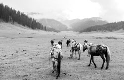
was joined by hundreds of other mules carrying ration. I came to know that
in the four months the troops on the posts had been supplied with ration
which they had stocked for the entire year because August onwards the tracks
are covered with snow and cannot be negotiated. The huge number of mules
with bags of ration and hundreds of men then started the steep climb. There
were many beasts, scores of them without a burden on them, and on inquiry I
was told that these were female mules and, as the male mules did not move
without the female mules leading the way, they were a necessary motivation.
How very human, these mules seemed to me. It was an addition to my
knowledge because I had thought that the mules were neutered but even in
that state the gender differentiation plays a hidden yet decisive role. And, finally, the climb
started. It was like going up a staircase. The mules huffed and puffed,
sweating profusely, displaying amazing stamina and an incredibly firm
foothold as I hung on desperately, being not used to riding horses or mules.
At many a moment, I closed my eyes thinking this was the end as the mule
would never be able to traverse very narrow paths drawn like a line on a
very steep slope and I will end in a ditch, the bottom of which could not be
seen. But I was reassured by the composure of the Animal Transport (AT)
personnel who held the mule by the bridle. At dawn we had started at
around 6,000 feet above sea level and were to reach 14,000 by early evening.
At about twelve, we rested at a midway point where some open space had been
carved and it served as the interchange point for mule trains which were
coming down from the top. After half an hour, the
ascent started again and, by mid afternoon, I could catch the snow on the
mountain peaks with the sun shining on them. We had left the thick
forest behind us and were almost at the end of the grassy slopes, a natural
grazing ground and were nearing the snow line with the craggy edges of the
mountains becoming more visible with snow wedged in the crevices. It was
otherworldly and ethereal, except for the enveloping fear of the mule losing
its foothold. The ascent continued like a staircase and by the evening we
reached the post of my saviour the major who was waiting for me eagerly
with open arms. He had not seen a person
from the plains for the past six months since he returned from his yearly
leave. His staff let go a volley of shots which echoed in the open spaces
and a volley of shots rang back as in reciprocation. I was told that the
Indian checkpost across the ridge had been informed that a guest of the
major had arrived and they had responded by joining in the welcome. caption Horses (or mules?)
carrying bags of ration, are led by men in their steep climb.
Pakistans northern part
is indeed a trekkers paradise. 10 out of 25 highest peaks are situated
here and it is also the most heavily glaciated region. This extreme
landscape boasts some of the best trekking routes in the world such as
Concordia and Snow Lake treks. Trekking experts believe
more than 2,500 trekking routes of different categories are found in the
northern areas of Pakistan such as Gilgit-Baltistan, Chitral, Swat, Kaghan
and Kashmir. Most of the trekking routes are in the northern mountains of
the Hindukush, the Karakorams and the Himalayas, says Aftab Rana,
President, Sustainable Tourism Foundation, a non-government organisation
that arranges trekking tours for youngsters on non-profit basis and also
trains guides in different trekking regions of the country. Over 200 trekking
routes [in Pakistan] are famous the world over and have been quoted in
different guide books, he adds. Treks here can take you anything from
a day to three weeks. Besides, these are strenuous as well as easy; short,
moderate and long. The best trekking season is between May and October. The government of Pakistan
has defined trekking as walking below 6,000 metres and it has identified
three trekking zones open, restricted and closed. Foreigner trekkers
needs permit from the federal Interior Ministry and the provincial Tourism
authorities to trek in restricted areas while no trekking is allowed in
closed zones, i.e. areas near Pak-China or Pak-Afghan border and the Line of
Control in Kashmir. The closed zones include any place within 30 miles of
the Afghan border and within 10 miles of the LOC. Most treks in Pakistan are
quite remote because they start at the least accessible village and many
cross glaciers and difficult terrain. We dont have a tea-house system
like they do in Nepal, says Abbas Ali Khan, an Abbottabad-based trekking
guide who has been in the business since early 1980s. Besides, very few
treks go through villages, which means the trekking parties must be
self-sufficient. This makes the entire exercise an expensive and tough
proposition, as the trekkers need to carry a lot of stuff with them. This stuff includes
camping gear, weather-appropriate clothing and footwear, and Odds &
sods like torches, candles, matches, silverware, mobile phones, etc.,
besides consumables such as medicines. Abbas says that trekking
expenses vary for local and foreign trekkers. Trekking can be as cheap as
for Rs500-1,000 per day per person in Margalla Hills to Rs9,000-10,000 at
Nanga Parbat to Rs15,000-20,000 a day per person on the Concordia trekking
route. It also depends on the size of the group. 10-12 is the ideal size for
a trekking group but as the size of the group shrinks, the expenses
swell. Although the companies
which arrange treks provide most of the equipment, the trekkers need to
bring a sturdy and comfortable backpack, a pair of sticks, flashlights,
raincoats and, most importantly, good boots. Sunglasses and hats are also
essential, no matter where or when you trek, especially on snow and
glaciers. Most of this stuff is very expensive; this is where the thrift
shops can come in handy. But dont forget to sterilise things before using
them. Guides and porters are an
integral part of a trekking team. A well-trained guide knows where to camp,
how to cook, where to find water and which path to follow. He has a complete
knowledge of the trekking routes and should have travelled the region
several times. A good guide also has knowledge of the rules and regulations
on trekking, the local culture, and he should be able to contribute to
making trekking a happy experience. Most of the guides are
licensed and work with different tour companies. They are paid by these
companies their wages var The porters, on the other
hand, are not licensed by the government, though their rates are fixed for
restricted zones every year by the government and for open areas the rates
can be negotiated. The rates for the
porters in restricted areas for the current year are fixed at Rs480 per
day, says Abdul Bari, owner of Lost Horizon Treks & Tours, a Gilgit-based
adventure tourism company. We provide all kinds of equipment as well as a
guide and a cook to trekkers. Thats part of our deals. Trekking in some areas
of Gilgit and Hunza is quite cheap, he adds. For instance, a 6-7
days trek to Raka Poshi base camp can cost round Rs20,000 per head while
treks in Skardu are very expensive and far more challenging. Salman Yaqoob, a
Lahore-based civil servant and a dedicated trekker for the last 20 years,
believes Pakistan has a lot of potential in the trekking sector. We just
need to develop the basic infrastructure [for trekking] and this sector
shall develop many times in years. He quotes the example of
Nepal which earns a good chunk of revenue from adventure tourism alone.
It is many times more expensive than what it is for trekkers in Pakistan.
We need to build at least log-huts or tea houses on the famous treks. It
should help to produce jobs for local communities and trekkers. Availability of good
quality canned-food and trekking equipment are other issues to tackle in
Pakistan. Tourism has decentralised after the promulgation of the 18th
Amendment and now it is the responsibility of the provincial governments to
work proactively on this. Most of the local companies in Gilgit-Baltistan
region are doing a good job, but the problem starts when you cannot find an
adventure tourism company in other areas. We also need to train
our local guides, says Yaqoob, adding that rates must be fixed [with
porters] beforehand even in restricted areas. They tend to exploit the
trekkers. There is another side to
the picture. After 9/11, the number of foreign trekkers has dropped
drastically. Security issues have taken a toll on the trekking-tourism.
Earlier, we would have 15,000-20,000 foreign trekkers and mountaineers
every year, but today the number doesnt exceed two thousands, says
Aftab Rana, because most of the countries have issued travel advisories
to their citizens for Pakistan. Our security agencies, too, have made it
tougher and more complicated for foreign trekkers. The foreign trekkers now
need to get permit from the federal Ministry of Interior followed by the
provincial Interior and Tourism authorities. Our agencies discourage
them, with the result that a lot of trekking groups come to Pakistan but are
forced to go back without trekking, because they cannot get their permits in
due time, he says. It is true that there are some security issues in
some areas, but most trekking routes are safe. The role played by the
government agencies is also very disappointing. In Indian held Kashmir,
tourism is again touching heights because the India now regularly sends
delegations to different countries to convince their governments to cancel
travel advisories. Our government has done nothing in this regard. The government also needs
to issue a code of conduct for trekkers and tourists. In the words of Aftab
Rana, Majority of them [trekkers] dump their waste along the trek. This
causes a great deal of environmental and health hazard. We need to involve
local communities and educate our trekkers about the cost of environment. caption Foreign trekkers need a
special permit for restricted zones.
Gearing up Thirty-five years
ago, there were few Pakistani trekkers. And, there was no trekking equipment
to be had anywhere in the country. We made do with second-hand army
haversacks that were ill-fitting, cumbersome and not capacious enough to
carry food and gear for a five-day trek. Those few trekkers who
were sufficiently well-heeled to travel abroad purchased their equipment
outside the country. The less fortunate of us considered it our good luck to
be friends with them to be able to borrow their gear. That was a time when
tents were what we needed the most. There was, of course,
Adventure Foundation Pakistan with its stock of gear available only (and
only!) for members. Since AFP disapproved of solo trekkers they always
went in large groups some lone wolves turned up their noses at becoming
AFP members. Such soloists were the hardest pressed for want of gear. Things eased off
considerably in the early 1990s with the setting up of, firstly, Higher, a
manufacturer from Ravi Road near Minar-e-Pakistan. A few years later, came
Adventure Shop on Poonch Road, Lahore. Suddenly, backpacks of various
capacities, sleeping bags, wind cheaters, fleece jackets, tents and most
equipment necessary for a comfortable trek became available to the local
adventurer. The best thing was that the quality was comparable to any famous
brand name from Europe or America at a fraction of the price. Pieces of equipment like
headlamps, torches, stoves, knives, ice axes etc are not locally
manufactured. However, Adventure Shop maintains reasonable stocks of these
imported items. The one item that is still hard to come by is a reasonable
pair of walking boots. A good pair will cost about US$200. This is a price
many are not willing to pay and, thus, there are no imports. Buyers will
settle for a Chinese manufacture for Rs3,000-5,000. Though these items look
sturdy, the sole is fixed on a base of poly-urethane which rots within
months of manufacture. Do not be surprised, therefore, when the sole, hardly
chipped, simply peels off in the first couple of kilometres of walking. Having said that, it must
be known that gone are the days of boots that lasted through the years and
an estimated 1,200 km of walking. My last pair, a Berghaus (worth £130 in
2006), lasted all of 500 km before the sole peeled. I currently use a pair
of Hoggs farmers boots purchased at the Sunday market in Ulverston (Lake
District) for a mere £40. They have gone about 200 km and doing well. Salman Rashid
Detailed maps are
considered the most important thing trekkers need to have on multiple treks.
Unfortunately, detailed and up-to-date maps of trekking areas of Pakistan
are not commonly available. Survey of Pakistan is one
department that is responsible for mapping the country but it does not issue
detailed maps of Northern Areas and Kashmir for public; it releases maps
only for the army. And, if a trekker is caught with maps at some
checkpost, it can create serious problems for him/her, because the maps are
termed national secrets. Salman Rashid, one of the
most celebrated travel writers in the country says finding detailed maps of
treks and trails in the northern areas is a gigantic task. In fact,
trekkers and mountaineers dont have access to Pakistani topographical
maps prepared by Pakistani authorities. The best available maps on our
northern areas can be downloaded from the website of the University of
Texas. But they measure at a scale of one-inch-is-equal-to-four-miles,
whereas detailed maps need to be measured at one-inch-is-equal-to-one-mile
scale. Salman recalls how in 2010
when he went to India he was amazed to find detailed maps of local treks
that came up to Western standards. They were brilliantly detailed and
easy to use. In Pakistan, you need a reference of an army officer of at
least the brigadiers level in order to access such detailed maps. The maps of the Indian
subcontinent, published by Bartholomew & Sons, UK, and the more precise
Nelles Verlag maps come in handy if you want to have a general sense of most
parts of northern areas, but they have limited value for trekkers. The U502
Pakistan and India (Jammu & Kashmir) series by the USs Army Maps
Service (AMS) are considered to be more detailed, except that these were
completed back in the 1940s and never updated. So, they lack the current
information on road infrastructure and villages. They are useful but not
much, as they have been updated, says Aftab Rana. Some German maps on
Karakoram and Swiss trekking and mountaineering maps are also available.
They are good for specific areas, such as the two maps of the Baltoro
Glacier one, prepared by a Japanese which is based on the K2 expedition
of 1977 and the other prepared by Italians based on their 1929 and 1952
expeditions. But, generally speaking, maps are a big problem area for
trekkers in Pakistan and they have to depend heavily on local guides for
description, says Abdul Bari. Survey of Pakistan used to sell maps to
foreign trekkers but over the last one decade or so it has refused to do so
because of security reasons. According to Aftab Rana,
most western maps are accurate but it is tough to understand the village
names in them. A lot of changes have occurred in these areas over the
past few decades. For instance, the villages have relocated or been renamed,
while the translation of names from Balti language to English is terrible
[in these maps]. All this makes it hard
for the trekkers to understand which area they are going to be trekking.
Its sad that almost all trekking routes of Pakistan lie in sensitive
areas. We need to overcome this paranoia if we mean to promote tourism.
Here, we can learn a lesson from India.
Here you can be
assured of being greeted with an incredibly warm welcome and awe-inspiring
scenery. Himalayas, Karakorum and Hindu-Kush ranges all collide here. Its
raw and breathtakingly beautiful. Ask me. The wilderness and wide
expanse of Deosai plateau (second largest in the world) is one such place
amongst a wide choice of trekking destinations in North of Pakistan. In
fact, we are terribly spoilt for choice, if we only looked deeper. Just five
weeks into completing the Everest Base Camp trek but still desperately
itching for more, brought me one step closer to Baltistan where this time
around a subtle and desolate trek awaited. A similar euphoria and
adrenaline rush that found its way to me on the Nepalese side of the
Himalayan range was now much more profound encompassing with an add-on sense
of pride. With a dedicated team of Skardu based porters and guides and with
complete faith in their local knowledge we set off on our week-long 4,000+
metres trek. It was not difficult to
immediately start relishing the company of simple, hardworking and nature
loving individuals taking pride in their work and rugged way of life. Its
a far cry from the lifestyle of a banker turned HR professional turned
Olympics organiser expat like myself. But for these reasons alone, I find
myself drifting away into the wilderness every so often and becoming one
with mother-nature. What a treat to be fishing
for fresh trout and then grilling it straight to our slippery plates and
hungry stomachs! What a privilege to be the
only ones surrounded from head to toe in boundless natural beauty and be
living the travellers dream! What a delight to be able
to spot a scurrying golden marmot and some not so discreet Himalayan bear
trails! What a sensation to wade
barefoot and knee-deep through ice cold river! What a feat to overcome
sheer exhaustion with the power of the mind after some 12 hours of
undulating trekking! What an absolute pleasure
to be in the company of simpletons, singing heartfelt Balti songs! What an honour to tread on
the path of some of the great mountaineers of the world! Those bearing a love for
the mountains know very well the aesthetic joy and peace of mind they bring
to the beholder. You cant help but dig deep and know that benefits of
which are at times intangible. One discovers the enormous
reservoir bubbling inside, including not only the physical strength to
endure the difficulties of uphill trekking and roughing it up but also the
mental strength to organise, persevere and meet challenges head on. For me, the mountains are
mysterious, with their own unique magnetism. They are a never ending source
of bliss and peace of mind. They have the innate ability to attract nature
lovers, trekkers, climbers, writers, artists, daredevils and pilgrims over
the millennia. Its no wonder that the ancient Chinese considered
mountains to be the source of vital energy, inspiration and awe. The combination of
physical exertion, abundance of natural beauty and fleeting moments of
spiritual clarity make trekking an addictive pastime. Ive been asked many
a time as to why I put myself through such physical torture. The spirit of
doing something for charity is one thing and putting your mind to such a
feat is about overcoming all forms of fears and dependencies. Its also
the peace and settling of mind that the rhythm of such a long trek can
bring. Minutes turn into hours as you trek along, only consumed by your
thoughts in a perfectly serene setting. One is only tempted to reflect,
introspect and then some more. Its almost about
looking beyond the day to day things that drag us down and inevitably make
us forget our dreams and aspirations! I mean it when I say, Sky is truly
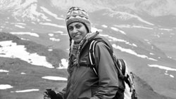
the limit! caption A banker turned HR
professional turned Olympics organiser expat, she was often asked why
shed put herself through such physical torture as she completed the Everest Base Camp
trek. On to the desolate trek in Baltistan.
|
|


 ld
take me to get to the other side. Perhaps a full day, perhaps two. When I
asked the locals, they said it would not take me long. Yeh khara hai!
(Here it is!), they said.
ld
take me to get to the other side. Perhaps a full day, perhaps two. When I
asked the locals, they said it would not take me long. Yeh khara hai!
(Here it is!), they said.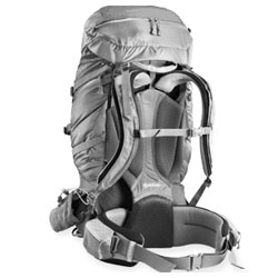
 y
from Rs1,500 a day for an easy trek to Rs5,000 for tough treks, while the
companies charge between Rs2,000-15,000 per guide per day depending upon the
nature of the trek. All related expenditures (of the guides) are borne by
the company.
y
from Rs1,500 a day for an easy trek to Rs5,000 for tough treks, while the
companies charge between Rs2,000-15,000 per guide per day depending upon the
nature of the trek. All related expenditures (of the guides) are borne by
the company.