


|
|
|
|
  
|
adventure
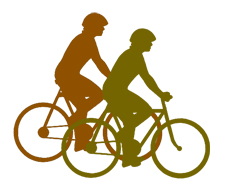
To pass on the bike
adventure
To pass on the bike If you have heard
people claiming to have travelled in Pakistan from one end to the
other, take it as no more than a figure of speech. I thought such a sweeping
contention should, for a start, entail a boat ride to the fabulous Astola
Island in the Arabian Sea, 30 miles south-east of Pasni; and, no amount of
travelling inside Pakistans heartland can be considered complete unless
the sojourn is rounded off with the ultimate feat of reaching the
northern-most latitude of the country. That extreme geographical
point was the goal of our two-man bicycle expedition last May, so we could
proudly flaunt our end-to-end travel credentials. Most ordinary maps show a
small kink jutting into China, a few miles north-east of the point where Pak,
Afghan and Chinese borders meet, being aptly described by the British
explorer Colonel Schomberg as the solar plexus of the mountain system of
Asia. Astride the kink is the 15,840-ft high Kilak Pass, which fans out
northwards into a sprawling snow-clad pasture. Here, herdsmen from
Pakistans northern-most village of Misgar come to graze their sheep and
goats, when the melting carpet of snow starts to uncover the rich herbage in
May. Up to the end of the 19th
century, the pass was infrequently used by traders from Gilgit and Hunza to
sell dried fruit and, of all items, wretched slaves with the acquiescence
of the heartless local rulers to caravans plying between the fabled oasis
towns of Western China and Afghanistans Badakhshan province, and beyond.
Much of the goods from China, however, came through the nearer Mintaka Pass
and, included silks, printed textiles, carpets and jade products, mostly
destined for the ruling elite of the region. Like most mountainous
passes, Kilak and Mintaka were also notorious for being hideouts for brigands
to waylay caravans laden with those exotic wares. Some of the infamous
outlaws of Gilgit and Hunza had spent their useful years prowling the crags
and defiles of these passes, while living off the land in the company of wild
animals and, lashed by bitterly cold winds. I could almost hear the nervous
whistles of marmots scampering about at the snarl of a hungry snow leopard in
that mountain vastness, as I started to plan the expedition. When I broached the subject
with my friend Shahid Dad, last year, he seemed sufficiently enthused.
Would you be willing to bike all the way from Gilgit to the extreme north
of Pakistan? I inquired carefully, lest he take it as an indolent
suggestion. The strong fighter pilot
bond we had shared in yesteryears came through when he emphatically replied
in the affirmative. When he added in his usual scholarly manner, Age
doesnt matter, the heart is still young, I knew I could take comfort,
knee joints and all! It was summarily decided
that Shahid would be returning from Boston the following May, especially for
this expedition. I promptly purchased lightweight mountain bikes for the two
of us from Nila Gumbad, Lahores crowded cycle mart. Getting those
retired muscles back to vigorous work was a challenge, and the coming
months saw me pedalling feverishly every morning on the outskirts of Lahore,
while Shahid was mostly confined to a gym due to severe cold weather in
Boston. The expedition was to last a full fortnight, from Gilgit up to the
northern limits of Upper Hunza Valley and back in 50km daily stretches, so
the demands on endurance and stamina had to be painstakingly catered for. While physical conditioning
was underway, the equally important planning aspects were looked into,
critically. Choice of route, basically dictated by suitable night stops, was
followed by selection of nearby inns, motels or camping sites; geographical
coordinates for GPS, climb gradients, astronomical and weather data were then
gathered. Most important, satellite pictures from Google® earth, which could
be viewed in amazing 3-D ground-level panoramas, were downloaded, carefully
analysed and then uploaded into our mobile phones for enroute correlation.
With a Mandarin vocabulary limited to nin hao and xiéxié, explaining a
border violation to Chinese guards would have been a disaster; good
navigation was, thus, the key to a successful mission. The problem of Acute
Mountain Sickness also had to be tackled. The earliest mention of this
sickness is known to have been made by a Chinese official by the name of To
Kan in 32 BC, while he was touring in the vicinity of the Kilak Pass itself.
A mans face turns pale, his head aches, and he begins to vomit,
observed To Kan. This malady afflicts even the very fit mountaineers if the
rate of vertical traverse is more than 2,000ft in 24 hours, above an
elevation of 8,000ft. Such a situation was going
to be encountered during our last leg. So we decided to break it up at the
half way point. With the vitals adequately
taken care of, we were rearing to go. On April 26, I departed for
Islamabad where I met up with Shahid who had arrived from Boston a few days
before. Next morning, we boarded PIAs ATR-400 turbo-prop for Gilgit under
command of a very helpful and friendly captain. The bikes had been
transported to Gilgit by road earlier, as the baggage hold of the ATR-400 was
found to be too small for bike cartons. In Gilgit, we promptly assembled the
bikes and went off for a familiarisation spin to the nearby town of Nomal,
which we nostalgically remembered having passed by nearly four decades
earlier, while on a tough route march during a survival course as cadets. Riding the rather dazzling
bikes what, with Darth Vader helmets and chic Polaroids® to complete the
striking figures we must have looked like creatures from Pluto, as we
swished past the curious bystanders. After returning from the test run, we
rigged the bikes with pannier bags, tents and sleeping bags and, carefully
calibrated the bike computers to help us keep track of speeds and distances
during the expedition. Finally, on April 30, we
set course for our first destination, Chalt. The Karakoram Highway (KKH) was
in good shape and pedalling seemed like a breeze. The resplendent Common
Magpies (Pica pica) in their black, white and iridescent green feathers were
to become a common sight throughout our trip. Said to be the most intelligent
of all birds being from the clever crow family they cackled and
quacked delightfully as if welcoming us to their garden localities. A more
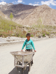
hearty welcome came from the village children who would run alongside our
bikes, chanting, Hello, one penny please. Wed respond with salaams
and good wishes in Urdu, but some of the kids would insist that we were
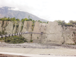
angraiz and, would keep on pestering for pennies! After a tough 50km leg, we
approached Chalt by a suspension bridge and, to get our legs in normal
working order, walked some distance to an old PWD rest house that had been
booked in advance. The facility had seen better times during the Raj
comfortable bungalow, according to the 19th century explorer Sir Aurel
Stein but even now, it wasnt too bad for a nights stay. A hot bath
before sleep and, a hearty open air breakfast at the nearby River View Hotel
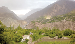
put us in top gear for the next leg. Hunza evokes thoughts of a
fabled land where everyone lives long, and happiness seems to be a gentle
breeze that blows the year round. We had been to Hunza previously in hurried
affairs, but never as merrily as this time, on bikes. Leaving Chalt, which
also marks the northern limit of Gilgit District, we had to negotiate a steep
climb over a highway that suddenly was no more. The KKH was under major
repair from Chalt onwards, and we found ourselves huffing and puffing over
gravel and shingle, an ordeal that was to last till our final destination,
all of the remaining 200kms. As we approached Hunzas
main commercial town of Aliabad after a very steep 50km leg, which took us
nine long hours to cover, courteous adults and cheerful children made us feel
quite welcome. Following the unfortunate spate of sectarian killings a few
weeks earlier, tourism had come to a complete standstill in the region; now,
we seemed harbingers of better times to the locals. Having no energy left to
climb yet another 2,000ft to the Eagles Nest Hotel perched atop a sheer
cliff beyond Duikar village, we hired a pick-up to haul our bikes. Just in
time to catch the ginger and orange glow of the setting sun bouncing off the
snow-clad mountains, we enjoyed the dazzling spectacle from the hotel
terrace. Not too far in the sky, the crow-like Red-billed Choughs (Pyrrhocorax
pyrrhocorax) in their glossy black plumage could be seen performing some
spectacular aerobatics in the mountain updrafts. While climbing up, we had
noticed scores of youngsters returning to their homes in the nearby towns
after a day-long picnic at Duikar. Interestingly, there was no segregation,
much like the rest of Hunza and, one wondered if this might be one of the
possible reasons for bliss in the happy valley! Later at the hotel, a short
dinner for two turned out to be a huge serving for four; though not quite a
master of Burushaski, I suspected that the order for alto (two) was conveyed
as walto (four) by the waiters to the cooks. Well fed and tired to the
bones, we were almost sleep-walking back to our rooms. The third leg promised to
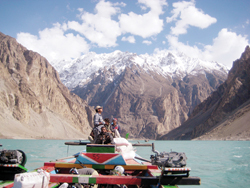
be different as we had to negotiate the 18km long Attabad Lake that, in one
of the vagaries of Nature, came into being three years ago as a result of a
massive landslide damming the Hunza River. We arrived at a dirty little
jetty, where disorder and confusion vied with dust and a merciless sun to
rile the coolest of nerves. It took some tough shouting to ensure that our
bikes were not mishandled as they were hauled onto the boats. Thereafter started a
90-minute ferry, what with a deafening putter of the diesel motors for a
serenade, as we watched the reflection of the towering mountains in the
turquoise waters of the lake. Disembarking a little short of Hussaini, we
found ourselves in Gojal Tehsil or the Upper Hunza Valley, where Hunzas
Burushaski language gives way to the Afghan-linked Wakhi for the most part. Already tired and profusely
hungry, the stretch from Hussaini onwards to Pasu was torment for our lower
limbs. We had to get off the bikes when even the lowest gear refused to
generate forward motion over the precipitous mountains. After a good two
hours of lugging our wobbly selves along with the bikes, we finally hit
downhill. In the fading light of the day, a Welcome to Pasu road sign
came as a godsend and we raced to get to Sarai Silk Route, a small but
adequate hotel. As everywhere else, our requirements centred on a hot bath
and enough to eat, both of which were available promptly. Over dinner, our waiter who
preferred to speak only in English, explained that he was basically a tourist
guide and in this lean season, was doing odd jobs. Those with better means
were offering the services of their vehicles to the locals to get to the
ferry at Hussaini and back. The Attabad Lake has
hampered the movement of tourists as well the locals, who have to pay hefty
amounts to get their goods across. A permanent solution seems years away,
though it is my considered opinion that two modern berths at either end,
suitably equipped with cranes to service heavy duty barges, might be a
functional interim solution. The hearty dinner we had at
Pasu gave us reason to rest an extra day, for Shahid had taken ill not long
after the meal. In the meantime, I sauntered around the apricot and apple
orchards and, took some striking pictures of the Cathedral Spires that are
best visible from Pasu. The day after, we set
course for the fourth leg to Sost, which is the dry port for trade with China
via the Khunjerab Pass, 80km further east. After another arduous day
of cycling which saw us through the beautiful village of Khaibar where
everyone looked like a Bosnian or a Croat we arrived in Sost. A rather
shabby town despite the natural beauty all around, we were hard-pressed to
look for accommodation. Due to an unusual influx of two busloads of Japanese
tourists, the PTDC Motel was fully booked; however, we were permitted to set
up our tents at the little camp site in the hotel premises. Once again a hot
bath and, some very appetising food served by a most eager-to-please waiter
Shamsuddin, lulled us to an early sleep. It was a wonder that,
having biked for more than 200 kms over a rubble of a highway, our cycles
held out, with not even a puncture to stop our progress. We were glad that
much of our cycling was over, but in all earnest, we knew that the remaining
trek wouldnt be Boy Scout stuff. Physical rigours had expended the last of
our calories and will power had been sapped to the last grimace. Kilak Pass
was still 7,000 feet above and, a perilous 55 kms beyond. Our trainer in boot
camp of yesteryears, the late Sqn Ldr Sabir, had always reminded us that when
all else is spent, determination surely lends a helping hand. We had loads of
it and it was time to tap into this resource. kaiser_mach2@yahoo.com To be continued
|
|