


|
|
|
|
  
|
development By Zahrah Nasir The bright red Citroen 2CV that I hired back in Dingwall, on the East Coast of Ross-shire, looks like a ladybird ready for take off with its two front doors open and roof rolled back in the heady warmth of a Scottish Highland summer morning.
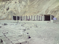
Cost of expansion The Karakoram Highway expansion project has already begun without a meaningful environment impact assessment and with huge risks to the cultural and historical heritage of the area By Aziz Ali Dad The construction of Karakoram Highway ((KKH) in 1978 was
an example of human success in diminishing his subordination to natural
forces and constraints. Globally, though, the initial euphoria of human
triumph over nature proved short-lived. It was realised that the dominance of
man over nature was not without a cost -- in the form of natural resource
depletion, global warming, ozone depletion and their repercussions. Therefore Environmental Protection Agencies (EPAs) were set up across the globe in order to safeguard the earth from the detrimental effects of rampant and unbridled development. EPA, established in Pakistan in 1993, extended its sphere to Gilgit-Baltistan in 2007. This was imperative because the region is characterised by fragile environment. Like elsewhere, EPA Gilgit-Baltistan was responsible for a detailed study of development projects against indicators of physical, biological and socio-economic impacts. Soon after the setting up of EPA, Gilgit-Baltistan witnessed a mega project -- improvement of KKH. The project inked on Nov 26, 2006, commenced work on July 3, 2008. The total cost of project is estimated at US$ 490, 8723, 43 (four hundred and ninety million US$). The contract for the project has been awarded to China Road and Bridge Corporation (CRBC). In the initial phase, the project covers the area from Khunjerab to Raikot Bridge. Between these two points KKH runs parallel with Hunza and Indus rivers, crosses Khunjerab National Park, negotiates the archaeological sites and historical village and touches the borders of the proposed Central Karakoram Park (CKP). Therefore, EIA of the project of such a mega scale becomes essential. As per the ToR of the project, CRBC is responsible for its EIA. Although the work on KKH expansion has already begun, no EIA report has been made public. The issue of environmental sensitivities of the project was not highlighted in the media. These involve impact on watershed areas of Indus River, endangered wildlife in Khunjerab and Central Karakoram National Park area, environmental contamination, waste water and solid waste of camps. Ideally an independent monitoring consultant (IMS) ought to monitor the project activities against Environmental Management Plan (EMP). The IMS will prepare a non-compliance report for National Highway Authority (NHA), and the latter will submit it to EPA. But none of these issues have been addressed so far. It is common knowledge that the consultant conducting EIA has already prepared a report without consulting public, line departments and NGOs. There are reports of glaring discrepancies in the EIA report. EIA report helps in understanding the situation on ground. In the absence of the report, the only way to gauge the impact of KKH expansion on different spheres of life of Gilgit-Baltistan is to take stock of project activities in the light of guidelines provided by EIA indicators. Some of the activities of the contractor on KKH expansion project in Khunjerab National Park (KNP) are in clear contravention of sub-section 1 to 12 of section 12 of Wildlife Preservation Act NAs 1975 and United Nation Convention on Biological Diversity. For instance, the former clearly states "no person shall reside in a National Park." Despite these prohibitions the contractor has built permanent structures by destroying vegetation and cutting slopes, and operating machinery that might not be in compliance with National Environmental Quality Standards. Passing the whole buck of such practices only on the
contactor is not fair, because, as a foreign firm, CBRC may not be cognisant
of the details of country and customary laws that regulate the affairs of the
region. Indeed, it is the foremost responsibility of local administration to
guide the contractor about the unknown legal terrain and local ethos of
Pakistan and Gilgit-Baltistan respectively. It is said that the high
officials of Gilgit-Baltistan administration have identified the sites for
camps on Khunjerab National Park. In clear connivance of their duties, they
gave permission of constructing permanent structures on it. Allowing such practices without necessary safeguards will nullify the achievements of KNP that was established in 1975 with the cost of Rs47 million. Environmental degradation of KNP will put the lives of 87 species of birds and 24 types of mammals at risk. The mammals include endangered Marco Polo sheep, Brown Bear, Indian Wolf, Himalayan Ibex, Golden Marmot, Snow Leopard, Common Red Fox and Blue Sheep Cape Hare. The camping sites outside the national parks also need to be monitored because they are situated along Hunza and Indus River. A discharge of wastewater and disposal of solid waste into rivers will contaminate the water of Indus River, which is the lifeline of agriculture of Pakistan. Other than the environmental impact of KKH expansion, cultural and historical heritage is also endangered, as the expanded KKH will pass through some of the sites and villages having archaeological and historical importance. In Haldikish (Hunza), KKH passes through a site that contains the inscriptions and petroglyphs on the 'Sacred Rocks of Hunza.' It is a record of pre-Islamic period of history; the culture of Gilgit-Baltistan served as a link between China and Gandhara civilization. Since the culture of Gilgit-Baltistan is totally oral, it has no tradition of written history. Preserving historical monuments like Haldikish will help the region to save a concrete historical memory. Elimination of this historical record will make the region impoverished in terms of cultural history. The ancient site of Haldikish lies literally at the end of KKH on the right side. A further extension of KKH on the right side can have a detrimental impact on the culture and tourism of Gilgit-Baltistan in general, and Hunza in particular. Expanding the left side of KKH with a significant distance from the site can avert the environmental and cultural destruction, and the rocks of the site can be preserved according to the guidelines chalked out by UNESCO in its book on rock preservation methods. Across Hunza River, from the site of Haldikish, is the ancient village of Ghanesh. Ghanesh still maintains unique built heritage. Considering the historical and cultural importance of this village, Aga Khan Trust for Culture (AKTC) has conserved environmental and archaeological heritage of the village. This is a best example of development without any harm to cultural and historical heritage and inbuilt environment of the area. The conservation site has already lost two thirds of its land to land-erosion. Expansion of KKH will deprive the site of its adjoining open spaces that are part and parcel of the inbuilt environment. Instead of carrying out expansion activities in historical sites and villages alone by the implementing agency, it would be better to forge partnership with organisations that have the expertise and experience in heritage preservation. In addition to environmental and cultural issues, there is the issue of compliance of activities of the KKH expansion with local customary laws. Most of the project area falls in areas that are not settled. Issues regarding loyalty of land, individual, and common property in non-settled areas is managed through centuries-old tribal and customary laws. It is a potential fault line between development projects and local communities. Different line departments and NGOs tend to negotiate through these customary laws to avoid conflict with indigenous population. There is an apprehension among local communities that riding roughshod over local ethos and laws could lead to potential tension between them and the implementer of the project. To avert any untoward situation, it is indispensable to address the issues and areas that can create dissonance of interest between local communities and the expansion project. Making the expansion project of KKH congruous with inbuilt environment, cultural heritage and customary law will help removing the hurdles and make it a success story. Keeping the indigenous people discontent in the process of the expansion of KKH can resolve problems in short term, but cannot prevent the discontent from coming back with vengeance in the long term. The writer is a Gilgit-based social scientist. Email: azizalidad@hotmail.com
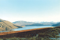
What will it be, north or south from Corrieshalloch Gorge? I'm feeling footloose and fancy-free so on the toss of a coin be it
By Zahrah Nasir The bright red Citroen 2CV that I hired back in Dingwall,
on the East Coast of Ross-shire, looks like a ladybird ready for take off
with its two front doors open and roof rolled back in the heady warmth of a
Scottish Highland summer morning. The drive, so far, has been stunning. In the one hour since leaving the small town of Dingwall, Scotland behind me, I have crossed northern Scotland, from east to west without even breaking the speed limit. The well-maintained road first wound its way through a series of tiny hamlets surrounded by towering forests of fragrant pine trees, then altered dramatically to purple heather moor land and mountains as I approached a red deer farm at Torrachilty where I made a brief stop by a tinkling burn to watch a huge herd of the animals tossing their antlered heads at annoying flies. Then it was back on the almost traffic less road to the lilting fiddle music of Alasdair Fraser, local musician of international renown, driving around fleecy white sheep sunbathing on the hot tarmac and on over the undulating road, the effect of being at sea as the car rolled forwards bringing to mind the coastal pleasures to come. Now, here I was in the car park at Corrieshalloch Gorge trying to decide whether to go straight on to Ullapool and then north to Achiltibuie and the Summer Isles or veer off, in a southerly direction, towards Gruinard Bay and the fabled Inverewe Gardens with their tropical palm trees whispering in a west coast breeze. I could stop in Ullapool, a picturesque harbour town astride Little Loch Broom where fishing boats congregate alongside car ferries destined for both the Inner and Outer Hebrides, and pick up the ingredients for a picnic on the broad sandy beach at Enard Bay just before Achiltibuie or, collect a picnic in the single Achiltibuie shop, then continue round the coast to a tiny rocky bay below Badenscalie and sit on the sea washed rocks there gazing longingly out at the Summer Isles. Alternatively, but still heading north, I could go down the single track, grass centered road towards Achiltibuie, past Stac Pollaidh, a fascinating outcrop of towering rock in the Inverpolly National Nature Reserve, the second largest such reserve in Britain, then take the tiny coastal road up to Inverkirkaig, have lunch in the little coastal resort of Lochinver and then drive out to the massive lighthouse at the Point of Stoer where millions of sea birds populate the cliffs and puffins flaunt their incredible tricks in the ocean itself. The scenery would be an unrivalled 'scape' of miniature stone houses, sandy and pebble beaches, the rolling sea and narrow sea lochs, massive mountains, peaty moorlands and lochans along with wild red deer and golden eagles if luck was on my side. It would make it a very long day before I crawled back east but the wild Highland splendour would give its own rewards. But, there again, going south offers a more soothing vista, equally wild but in a different way. First, soon after the turn-off, would be 'Desolation Road' through Dundonnel Forest, not a tree filled sanctuary as the name implies but an uninhabited expanse of high moorland festooned with pink heath, purple heather, waving fronds of green bracken and wild grasses with the occasional ruined remains of a croft here and there and eagles circling the majestic peak of An Tellach. Desolation Road is haunted by the invisible images of the hundreds of Highlanders, hauling their meagre possessions, who were herded away from their ancestral lands by their English overlords in the horrific Highland Clearances of the late 1800s when sheep became more profitable than people. The Clearances were responsible for thousands of indigenous Highlanders being forced, sometimes at gunpoint others out of sheer desperation, to board the ships that transported them to a 'new life' in America, Canada, Australia and New Zealand. I can't drive this stretch of emptiness without feeling their anguish. The steep descent through a deciduous riverine forest to the scattered hamlet of Dundonnel, at the head of Little Loch Broom provides spectacular views out to sea and the popular small hotel serves an excellent lunch along with mouth watering handmade chocolates. There is even a petrol station, which is very few and far between in this neck of the woods. From Dundonnel, the narrow road clings to the hillside on the left of the narrow sea loch before climbing up to Badcaul from which vantage point one looks across to the Scoraig peninsular, accessible only on foot or by a boat crossing, home to a tough little community of like-minded people who harness the wind and sun for energy. From here the road climbs again, the sparkling sea always in sight and swings southwards to Gruinard Bay, indented by coves of pinkish sand formed from red sandstone and an extremely popular tourist spot indeed. The shallow waters, ideal for swimming, are teeming with fish and crabs although they are not recommended for eating as, during the Second World War, the picturesque island out in the bay was used for experimental germ warfare and scientists still monitor the soil there for things including anthrax although, recently it was declared safe and put up for sale with, understandably, no takers. Leaving Gruinard behind the road meanders through isolated crafting communities to Aultbea on Loch Ewe and then onwards again through dazzling scenery to Inverewe Gardens, visited by tourists from all over the world. Almost on the same latitude as Leningrad and Labrador, Inverewe gardens are a sub-tropical wonder. This once barren peninsular was purchased by a Scottish Laird, Osgood MacKenzie in 1862 who quickly realised that the North Atlantic Drift, responsible for mild weather along this coast and that of Ireland, may encourage plants to thrive so set about creating his personal 64 acre pleasure gardens. He imported tons of top quality soil from Ireland, planted shelterbelts of hardy trees and then really let his imagination run riot. Now owned by the National Trust, the gardens are a complex maze of Monterey pines, Rhododendrons, Azaleas, Magnolias, Eucalyptus, Pineapples, Palm trees and hundreds of other stunning plants and shrubs. The craft shop is pretty good, the seed store great but the restaurant mediocre. Now. What will it be, north or south from Corrieshalloch Gorge? I'm feeling footloose and fancy-free so on the toss of a coin be it!
|
|