


|
|
|
|
  
|
visit More
fiction than reality
Travelling the length and breadth of Chakwal district, visiting its well known sites and exploring the unknown secrets of the area By Awais Manzur Sumra About a decade back my job
took me to Chakwal where I spent just over 18 memorable months. While in
Chakwal, I had the It was in Chakwal that I befriended Safdar Shah, a native of the district who had spent years looking for and visiting historical and interesting sites in and around the Salt Range. He became my source of information on many of the lesser known places of the area and accompanied me on some of my forays into the interior of the district. One journey, on which Safdar Shah accompanied me, took us to the top of Potohar on a hot and sunny day in May. Having left Chakwal under a blazing sun, we drove to Sarai just short of Choa Saidan Shah and then turned left onto the single and winding road leading up into the hills and the valleys beyond. We were in the Salt Range. Avoiding the daredevil local drivers and the occasional potholes, we soon drove past the town of Basharat a town with a sizable population at that time of Afghans who worked in the myriad coal mines that dotted the area and then through some eye-catching valleys. I found the drive from Basharat to Ara, a village on the eastern extremity of the district, particularly scenic with hills covered with dense vegetation interspersed with huge boulders. At places streams came cascading down from the hills and at others wild flowers, bright red in colour, brightened up the milieu. Numerous tiny villages clung to the hillside, their inhabitants busy in their daily chores in an atmosphere of peace and tranquility. Ara is located in an area
of the Salt Range that is generally known as Jhangar. The portion of the Salt
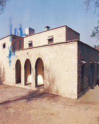
Range falling within It was just outside the village Ara that we came across the old Civil Rest House. A stone erected at a central place in the back lawn of the rest house transported me, momentarily, to some battle front in France with the WWI continuing to ravage the heart of Europe. The stone was carved into a yellow plastered masonry wall no more than three feet by six feet in size. It had the following inscribed on it in fading black letters: Sacred to the memory of Major Arthur Ian Fraser DSO, 9th Hodsons Horse, who fell in action in France on 30th November 1917. And the following words adorned the lower portion of the stone, This stone was erected by members of his squadron who live in this neighbourhood. The Civil Rest House stood at a vantage point a few hundred metres outside the village. The road wound down the Salt Range beyond the rest house. Another stone laid in the front wall stated that the rest house was established in 1917 and was raised from ruins in 1995 by the then Deputy Commissioner, Chakwal and the Assistant Commissioner, Choa Saidan Shah with the support and help of local people. That was, however, not totally true, according to Safdar Shah, whose native village lay just half an hours drive away. According to him, the walls were intact, and so was the roof. The rest house had simply been repaired and given a facelift. After that facelift, the exterior walls were adorned with rough stone, pale yellow in hue. The vantage point at the rest house afforded an exhilarating view of the plains of Jhelum and Pind Dadan Khan below. There was the light blue line of the majestic River Jhelum running from east to west far in the hazy distance. The railway track from Gharibwal to Malikwal made its way through the brown fields, wheat having been freshly cut, towards the river. The ruins of the famous Nandana Fort could just be made out on one of the smaller hills to the southeast. Safdar Shah informed me that, on a clear day, the town of Mandi Bahauddin could also be made out in the distance. As we stood there, admiring the sights below, the breeze picked up. The breeze was slightly warm but the sun was not unbearable, even on the May afternoon. We left the rest house and continued our journey to Chehl Abdal the highest point in the Potohar. Chehl Abdal was located at an altitude of somewhere between 3,500 and 4,000 feet above sea level and was said to be named after 40 elders who were believed to have come down from somewhere in Central Asia centuries ago and chosen that place to meditate. We took the road back from Ara to Basharat. Just short of Basharat lay the tiny village of Lari Shahnawaz. We turned right from the main crossing in the village to the road leading down the hills to Choa Gunj Ali Shah. To our left loomed the green hills upon which was perched Chehl Abdal. Soon we turned onto a kuccha road littered with stones of varying shapes and sizes. I had planned to take a jeep on the journey, but decided to stick to my car on the advice of Safdar Shah. The advice was, for once, wrong. The upshot, we had to disembark and walk most of the way up past the myriad coal mines. The last hundred metres or so comprised the steepest portion and had to be hiked up. The kuccha road was left below as it skirted the hills and led to the villages on the western side. We followed the edge of the hill in order to afford a better view of the valley to the east and south. The pale evening sunshine diffused into the vastness that lay before us. Basharat lay immediately below us, its brown coloured mud houses forming a remarkable pattern. We skipped over huge boulders, trying to avoid the small shrubs that sprouted out of the rocky crevices. Almost half an hour after abandoning our car, we were on the top. There was vastness all around, veiled somewhat by hazy sunshine. The view was simply enthralling. To the north and west were the plains of Chakwal. The waters of the Kot Raja Dam and the Khokhar Zer Dam down in the distance gleamed in the evening sunshine. To the south and east lay countless villages that dot the Salt Range. Flecks of clouds loitered aimlessly in the sky. Cool breeze made it difficult to believe it was May. At the top itself, a small mosque stood close to an open area enclosed within a whitewashed boundary wall. Inside the open area, a platform about two feet high had been constructed. Pieces of multi-coloured cloth hung at places and the rusting steel gate was shut but not locked. Nearby was a row of dilapidated small rooms, about ten in number, the likes of which are more easily associated with the ruins of Taxila and Takht Bhai. The elders who were believed to have come down from Central Asia to pray and meditate probably used the same place to meditate and those rooms served perhaps as their living quarters. But there was not a soul to be seen at the time of our visit. Immense vastness and eerie silence were our only companions. However, more than its history, which probably is unverified, it was the location, the drive and the hike up to Chehl Abdal that I found truly fascinating. I found the place ideal for those fond of hiking and trekking, providing something different from the much visited areas in the north of the country. Chehl Abdal can be easily visited by those spending a day or two in Kallar Kahar or Choa Saidan Shah. At the top of Potohar, there is immense serenity and calmness, coupled with the relatively pleasant weather even in summer. There is the ruggedness of the rocky hills, the occasional pungent smell of the coal mines and the extraordinary view of the Salt Range and the plains of Punjab on a clear day. Surely a place not to be missed. amsumra@gmail.com
Contrary to what some eminent travel writers are trying to prove, the Silk Road did indeed run through Pakistan By Aziz Ali Dad Until the explosion of
information technology and developments in communication in the late 20th
century, the genre of However, travelogues, with a few exceptions, also proved to be a source of myth-making. Salman Rashid, an eminent Pakistani travel writer, in his recent articles in English newspapers, including this newspaper, has ventured into a domain of history to prove his argument that the Silk Road did not run through Pakistan. Despite the fact that he is dealing with history, he has evinced evidence for his argument from travellers like Marco Polo and Wilhelm of Rubruck whose itinerary did not take them to the region of Karakoram. As a result, he ends up creating another myth that is diametrically opposite to what is proved by historical research on the Silk Road. In order to get a proper understanding of the Silk Road, it is imperative to take into consideration historical research that is based on the accounts of old travellers who traversed the region as well as archaeological findings. Unfortunately, the seasoned travel writer of Pakistan does not mention the former and employs the latter to furnish his argument that none of the rock carvings along KKH mentioned silk. Taking cue from this, he argues that it proves that no silk ever came this way. Therefore, Rashid declares, KKH being Silk Road is a fiction created by an unknown pigmy bureaucrat. In fact, there were two
major routes of the Silk Road spreading westward and southward. The Western
route went through Well before Marco Polo and Wilhelm of Rubruck, three famous Chinese pilgrims Fa-Hian, Sung-yun and Hiuen Tsang traversed the region in A.D.400, 518 and 630 respectively. They have described in detail people carrying valuable goods and gems while travelling. Fa-Hian describes a function in the region where an assembly was decorated with silken streamers and canopies are hung out in it and water-lilies in gold and silver are made and fixed up behind the places where the chiefs of them are to sit. It is illogical to assume that the traders and pilgrims chiselled 30,000 petroglyphs and 5000 inscription on the rocks and boulders but did not carry silk with them on the trading route with other goods. An important point to note is that Buddhism in the valleys of Karakorum became a great trading religion. Andre Wink in Al-Hind The Making of the Indo-Islamic World writes in the seventh and eight centuries we become aware of the presence of Indian Buddhist traders along the southern silk route, and Buddhist contacts were maintained between some valleys of the Upper Indus (e.g. Gilgit) and the Tarim Basin. Contrary to Salman Rashids views, historians on the Silk Road employed the very rock carvings to prove that southern Silk Road passed through the region of Gilgit-Baltistan. For example, renowned historian Dr Ahmed Hasan Dani in his book Human Records of Karakorum Highway declares Gilgit-Baltistan the centre of southern route of the Silk Road that opens a passage for trade to the Indo-Gangetic Plains. Aloka Parasher-Sen asserts that historically the region of Karakorum saw a continuous stream of people of diverse origin and languages flock her through the high altitude passes and along the banks of the river Indus diverting to various destinations after that. Unlike Salman Rashid who finds sub-continental Silk Road in India, this Indian scholar claims that among southern routes of Silk Road, the route of Karakorum was major one on which trade continued unabated. Until the conquest of Hunza by the British, the state of Hunza arranged marauding parties to plunder the caravans plying from Kashgar to Gilgit and other regions. I have fond memories of listening to my grandfathers stories about selection of strong men from villages to prepare a posse for attacking the caravans on the Silk Road. This was almost an annual ritual called breaking of Qaratang. If they werent attacking caravans, what were they out to loot in the snow-clad mountains? The Silk Road in Gilgit-Baltistan was not only a trading route but also a major conduit for cultural and religious exchange between South and Central Asia. To sift facts about the Silk Road from fiction, we ought to take into consideration oral history, artistic and religious symbols, collective memory and modern historical research. If we ignore these, we are condemned to rely on modern travellers who spawn more fiction than reality. The
writer is a social scientist based in Islamabad. Email: azizalidad@gmail.com |
|
 opportunity of travelling the length and breadth of the district, visiting
its well known sites and exploring the unknown secrets of the area. In
Chakwal, there was Kallar Kahar, a popular lake-side attraction for those
travelling on the newly built (at that time) Lahore-Rawalpindi Motorway, and
the not so well-known, but equally impressive, Choa Saidan Shah, with
peacocks roaming its lush green vegetation. There was also the breathtaking
Malot temple, perched on a precipice overlooking Lilla, and the unkempt
temple of Katas, reputed to be one of the holiest sites for Hindus.
opportunity of travelling the length and breadth of the district, visiting
its well known sites and exploring the unknown secrets of the area. In
Chakwal, there was Kallar Kahar, a popular lake-side attraction for those
travelling on the newly built (at that time) Lahore-Rawalpindi Motorway, and
the not so well-known, but equally impressive, Choa Saidan Shah, with
peacocks roaming its lush green vegetation. There was also the breathtaking
Malot temple, perched on a precipice overlooking Lilla, and the unkempt
temple of Katas, reputed to be one of the holiest sites for Hindus.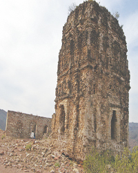 District Chakwal extends from Diljabba in the east, overlooking the Grand
Trunk Road between Rawalpindi and Jhelum, to close to the Sakesar hills to
the west in District Mianwali. The area falling in District Chakwal is
further subdivided into three distinct regions Jhangar, Kahoon and Wanhar.
Jhangar is the eastern most region and, out of the three, is considered to be
the best suited for agriculture. Jhangar is also rich in wildlife as urial,
chinkara, wild boar, jackal, fox and various species of partridges are found
there in abundance, while leopard and wolf also reported to have been
sighted.
District Chakwal extends from Diljabba in the east, overlooking the Grand
Trunk Road between Rawalpindi and Jhelum, to close to the Sakesar hills to
the west in District Mianwali. The area falling in District Chakwal is
further subdivided into three distinct regions Jhangar, Kahoon and Wanhar.
Jhangar is the eastern most region and, out of the three, is considered to be
the best suited for agriculture. Jhangar is also rich in wildlife as urial,
chinkara, wild boar, jackal, fox and various species of partridges are found
there in abundance, while leopard and wolf also reported to have been
sighted. travelogue remained a vital source to acquire knowledge about exotic lands,
customs and people. That is why travelogues fascinated curious minds and
historians for centuries.
travelogue remained a vital source to acquire knowledge about exotic lands,
customs and people. That is why travelogues fascinated curious minds and
historians for centuries.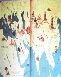 Central Asia to Mediterranean Sea. The Southern route has many arteries that
led to Taxila and Indian heartland. Among these arteries, the Kashgar to
Gilgit route was shorter and a major one. After studying new findings of
archeological research on human records in Chilas and Oshibat along KKH, an
eminent Indian historian Aloka Parasher-Sen in her research Beyond
Boundaries Travellers along the Karakorum claims that scholars now
fully agree that this was a crucial artery of communication for centuries.
Central Asia to Mediterranean Sea. The Southern route has many arteries that
led to Taxila and Indian heartland. Among these arteries, the Kashgar to
Gilgit route was shorter and a major one. After studying new findings of
archeological research on human records in Chilas and Oshibat along KKH, an
eminent Indian historian Aloka Parasher-Sen in her research Beyond
Boundaries Travellers along the Karakorum claims that scholars now
fully agree that this was a crucial artery of communication for centuries.