
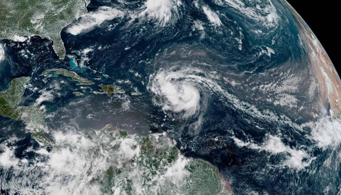
Hurricane Erin is strengthening rapidly as it moves over the northeastern Caribbean on Saturday, August 16.
As a result, it is causing rough seas, heavy rains and strong winds on nearby islands.
As per multiple reports, by Saturday morning, it had reached Category 4 strength with winds of 130 mph and was positioned about 150 miles northeast of Anguilla.
The storm is moving just north of the Leeward Islands, Virgin Islands and Puerto Rico as it slowly turns north.
Reports suggested that the storm probably won't hit these islands directly but warnings have been issued since they could still face dangerous weather conditions.
Erin is expected to move north into the western Atlantic next week, likely missing the US and Bermuda but if its path shifts, it could still be a threat.
Even without a direct hit, it may cause dangerous waves and rip currents along their coasts.
Erin, which is the Atlantic’s first major hurricane of the season is expected to keep getting intensifying on Saturday due to the warmer-than-usual Atlantic.
By the middle of the next week, the storm is predicted to become two or three times larger which will create dangerous and rough ocean conditions across the western Atlantic.
Considering this, the US Coast Guard officer in charge of San Juan has ordered the closure of ports in St.Thomas, St. John and six seaports in Puerto Rico to incoming ships, unless special permission is grated as a safety precautions.
So far in 2025, there have been four tropical storms named Andrea, Barry, Chantal and Dexter but no hurricanes yet.


